Sunday, February 22, 2009
Southwest to BOS
As reported last week, Southwest will start serving Boston's Logan Airport, (BOS), starting in the fall. For the story, check http://www.blogsouthwest.com/video/southwest-airlines-ceo-announces-future-service-bostonout the link from Nuts About Southwest's blog . For Information on Boston and Logan Airport check out:www.massport.com/logan/.
Saturday, February 21, 2009
LAX Overnight

The top photo shows my view to the North from my hotel room. You can see
the blue of the Hollywood Hills in the distance. As I took my walk to go to dinner and shopping, many planes flew over-head. The second photo has one of our Southwest 737's on short final.

The third photo shows Sepulveda Blvd. in the Westchester neighborhood
looking South toward LAX.
The bottom photo shows Trader Joe's across the street from El Tarasco. After
a hearty Mexican meal, I will enjoy shopping at one of my favorite specialty
grocery stores. www.traderjoes.com .


El Tarasco Mexican Resturaunt, Los Angeles

In the Westchester neighborhood, about a mile from our hotel, is one of my
favorite Mexican resturaunts called El Tarasco. Infact, the reason I enjoy coming to LA is to eat here and to shop at Trader Joe's across the street.
Check out the reviews here:http://www.yelp.com/biz/el-tarasco-los-angeles.
You can find El Tarasco here:
http://www.maps.google.com/maps?f=q&source=s_q&hl=en&q=&jsv=145d&sll=37.0625,-95.677068&sspn=33.710275,79.101563&ie=UTF8&geocode=FacsBgIdkmzx-A&split=0
The second photo shows the chips with their homemade Salsa.

The third photoshows some of the specials. The green card in the upper-right
corner shows the Special #34- Pork Green Chile, which is one I ate tonight.

The Food arrived promptly. As you can see the portions are huge! The meal
came with 2 Flour Tortillas, (top of the top photo). I divided the pork, beans
and rice in half and made 2 burritos, as shown in the second photo.
In the third photo, the left burrito, (wrapped in foil), is saved for lunch tomorrow as I eat the unwrapped one on the right. The food was excellent as
always, and dirt cheap. $6.99 for 2 meals. For an idea of some of the other
specials they have, click on the bottom photo.


came with 2 Flour Tortillas, (top of the top photo). I divided the pork, beans

and rice in half and made 2 burritos, as shown in the second photo.
In the third photo, the left burrito, (wrapped in foil), is saved for lunch tomorrow as I eat the unwrapped one on the right. The food was excellent as
always, and dirt cheap. $6.99 for 2 meals. For an idea of some of the other
specials they have, click on the bottom photo.


Flying LAX- PHX on Tuesday February 17th

Well they say "It never rains in Southern California", well today we had one of
those rare rainy days as we left Los Angeles. The top photo has a view of the
Western Phoenix area. Here we are able to see out as today the Valley of the
Sun only has some high clouds. The rain that hit California also hit the Phoenix
area as you can see how green the fields are in the top photo.
The second photo has a view above the Estrella Mountain Ranch Commutity,
www.estrella.com . As we fly over the Valley we see just how massively large
the Phoenix Metropolitan area is. Phoenix is now the 5th largest city in the
Untied States with a population exceeding 1.5 million. The Valley population is
over 4.5 million. Their isn't much of a "city feel" to Phoenix; but more a series

of sub-divisions and strip malls. Phoenix is trying to change this culture. In
recent years there has been a major re-vitalization of the Central Corridor and
in December, Phoenix's first light rail opened. Hopefully this will help slow down the out of control sprawl. www.valleymetro.org .
Phoenix is a great place to visit especially this time of year. The warm dry desert air promotes many outdoor activities. For more information:
www.visitphoenix.com .

The bottom photo is taken just south of
 the Phoenix International Raceway,
one of the stops along the NASCAR racing series. http://www.phoenixinternationalraceway.com, www.nascar.com .
We get closer to Phoenix and the Valley sprwal becomes denser, (top photo).

We fly South of Downtown Phoenix which can be seen through the clouds at
the top of the center photo.

In the bottom photo, we see the sub-divisions of Phoenix's Ahwatukee
neighborhood, which is South of Downtown on the other side of South Mountain.
If you want to see the whole valley while visiting Phoenix, a great way to do this
is to hike or drive to the top of South Mountain to the Lookout. http://phoenix.gov/parks/hiksogud.htm.
We head East of Phoenix where we will turn around and land to the West.
These 3 photos show the suburban sprawl of the rapidly growing East Valley
cities of Chandler and Gilbert. Gilbert made the list of the 5 fastest growing cities.
http://money.cnn.com/2008/07/10/real_estate/fastest_growing/index.htm.
For information on these two cities, go to: www.visitchandler.com or
www.gilbertaz.com .


These 3 photos show the suburban sprawl of the rapidly growing East Valley

cities of Chandler and Gilbert. Gilbert made the list of the 5 fastest growing cities.
http://money.cnn.com/2008/07/10/real_estate/fastest_growing/index.htm.
For information on these two cities, go to: www.visitchandler.com or
www.gilbertaz.com .


As we turn to the West to land at Sky Harbor, we fly over Mesa, AZ. Mesa is a
very large suburb with well over 400,000 people. In fact Mesa itself, is larger
than the cities of Cincinatti, St. Louis and Buffalo, (probably as a result of many
people leaving those upper midwest/rust-belt cities for the sunshine of Arizona).
www.visitmesa.com .
Mesa has grown mainly through sprawling sub-divisions and retirement
communties. The top photo has a view of the San-Tan Freeway
(AZ202 running vertical in photo, and US 60, (horizontal).The growth of the
freeway system has pushed Mesa, (and the Phoenix area
further east). To the left of the intersection and in the 2nd photo, you see two
of Mesa's many modular-home retirement communties
 The third photo down has a viw of downtown Mesa. You can tell how suburban
in nature Mesa is with only two buildings in dowtown for a city of 400,000. The
white building in the center of the photo is Mesa City Hall. www.cityofmesa.org .


The bottom photo shows the rush hour of cars commuting Northbound on
AZ 101
very large suburb with well over 400,000 people. In fact Mesa itself, is larger
than the cities of Cincinatti, St. Louis and Buffalo, (probably as a result of many
people leaving those upper midwest/rust-belt cities for the sunshine of Arizona).
www.visitmesa.com .
Mesa has grown mainly through sprawling sub-divisions and retirement
communties. The top photo has a view of the San-Tan Freeway
(AZ202 running vertical in photo, and US 60, (horizontal).The growth of the
freeway system has pushed Mesa, (and the Phoenix area
further east). To the left of the intersection and in the 2nd photo, you see two
of Mesa's many modular-home retirement communties

 The third photo down has a viw of downtown Mesa. You can tell how suburban
in nature Mesa is with only two buildings in dowtown for a city of 400,000. The
white building in the center of the photo is Mesa City Hall. www.cityofmesa.org .


The bottom photo shows the rush hour of cars commuting Northbound on
AZ 101

We fly over Tempe
 , a suburb just East of Phoenix with a population of
about 175,000 according to www.wikipedia.org . Tempe has a nice downtown
which runs along Mill Ave, (bottom photo), www.millavenue.com . Tempe is also the home of Arizona State University, (shown in the middle 2 photos).
www.asu.edu . For more information on Tempe check out: http://www.tempecvb.com.


Sunday, February 15, 2009
Flying BWI-PVD on Sunday February 15th

As we take off from BWI we turn to the east and we get a good view of
Baltimore and the Harbor, (all photos may be clicked on for greater detail).
From here will head northeast over the Jersey Shore. As we approach the New York area we head east over Long Island. At about the fork we head
over Long Island Sound into Providence, (PVD). The bottom two photos give us a good view of the Metropolitan New York area.


We head east from New York City over Long Island. The top photo is taken
overhead NewYork's John F. Kennedy Airport, (JFK). LaGuardia, (LGA)
the smaller domestic airport can be seen at the top of the photo. The two airports are just 8 miles apart. www.panynj.gov .
The next photo looks back at New York City from Long Island. At the top
of the photo you can see the George Washington Bridge which connects
New York with New Jersey, (top of the photo).


The bottom two photo are of Nassau County on Long Island. Long Island
is divided into 2 counties Nassau and Suffolk. Nassau being closer in is much
more dense with smaller housing lots. Suffolk is less populated with more
space.
As we head East over Long Island :
:
The top photo is an overhead of Republic Airport and General Aviation field
in Farmingdale, NY. www.republicairport.net .
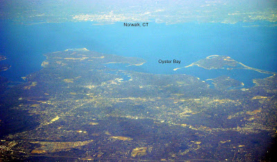
The second photo has a view of Western Suffolk County, NY in the lower half.
Southern Fairfield County, CT is clearly visible in the top half.
The third photo has an aerial view of MacArthur Airport, (ISP). Unlike the NYC Airports, ISP is hardly ever delayed. It is also very easy to reach which
makes it a very good alternative to flying out of LGA or JFK.
www.macarthurairport.com .

We cross Long Island Sound and pass over Point Judith as we begin our
descent.
 :
:The top photo is an overhead of Republic Airport and General Aviation field
in Farmingdale, NY. www.republicairport.net .
The second photo has a view of Western Suffolk County, NY in the lower half.
Southern Fairfield County, CT is clearly visible in the top half.

The third photo has an aerial view of MacArthur Airport, (ISP). Unlike the NYC Airports, ISP is hardly ever delayed. It is also very easy to reach which
makes it a very good alternative to flying out of LGA or JFK.

www.macarthurairport.com .

We cross Long Island Sound and pass over Point Judith as we begin our
descent.
As we reach Final Descent, we fly just to the west of Newport, RI. Newport
has been for a long time the summer home for the rich. The Kennedy's as
well as the Vanderbilts have had summer homes for many generations. You
You
can take a driving tour of the mansions, for more info: http://www.newportmansions.org. The area where the Mansions are located is marked in the top photo.
The second photo has the Harbor areas of both Newport and Jamestown as
well as the bridges you would take to get them from Mainland Rhode Island.
Newport and Jamestown two of the many islands that gave the state of Rhode
Island its name. The mainland part which borders Connecticut and contains
Providence, was once referred to as Providence Plantation.

The third photo down has a view of the Newport area and where the Mansions are in relation to Downtown and the Harbor. Newport is a great place to visit in the summer. For information check out: http://www.destinationnewport.com.
Finally, the bottom photo, has a view of Fall River, MA as well as Bristol, RI, (another, island of RI), as we turn to land NW at PVD. Providence Airport, (PVD) is a convenient airport and easy to get in and out of. It is a no-hassle alternative to Boston's Logan Airport. www.pvdairport.com .
has been for a long time the summer home for the rich. The Kennedy's as
well as the Vanderbilts have had summer homes for many generations.
 You
Youcan take a driving tour of the mansions, for more info: http://www.newportmansions.org. The area where the Mansions are located is marked in the top photo.
The second photo has the Harbor areas of both Newport and Jamestown as
well as the bridges you would take to get them from Mainland Rhode Island.
Newport and Jamestown two of the many islands that gave the state of Rhode
Island its name. The mainland part which borders Connecticut and contains
Providence, was once referred to as Providence Plantation.

The third photo down has a view of the Newport area and where the Mansions are in relation to Downtown and the Harbor. Newport is a great place to visit in the summer. For information check out: http://www.destinationnewport.com.

Finally, the bottom photo, has a view of Fall River, MA as well as Bristol, RI, (another, island of RI), as we turn to land NW at PVD. Providence Airport, (PVD) is a convenient airport and easy to get in and out of. It is a no-hassle alternative to Boston's Logan Airport.
 www.pvdairport.com .
Subscribe to:
Posts (Atom)


